
Maritime Visibility When
AIS Goes Dark
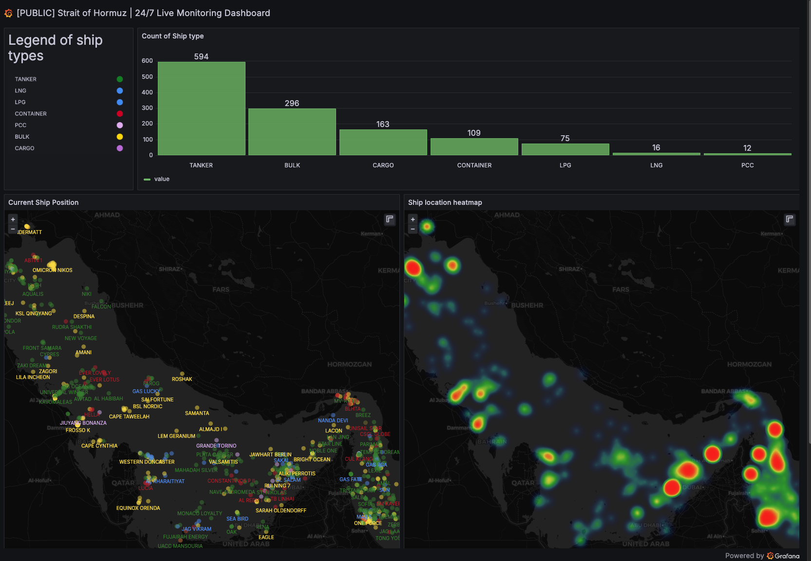
24/7 Live Monitoring of the Strait of Hormuz, Persian Gulf, and Omani Waters.
SeaVantage solves tracking blind spots through advanced maritime data intelligence. By filtering corrupted AIS signals and analyzing behavioral patterns, we reconstruct likely vessel movements even when tracking systems become unreliable.
Data updated every 15 minutes. Never lose sight of critical maritime assets.
Solving The AIS Blind Spot
Signal Disruption
Automatically detect when AIS systems are deliberately turned off or spoofed.
Route Validation
Verify reported positions against historical maritime traffic patterns.
Risk Mitigation
Monitor high-risk chokepoints with 15-minute refresh cycles.
Movement Reconstruction
Calculate likely vessel positions even when tracking signals are entirely missing.
Core Capabilities of Our Intelligence Platform
When traditional AIS signals fail, SeaVantage’s advanced algorithms take over. We ensure continuous maritime visibility in the world's most critical and congested waterways.
AIS Signal Filtering
Detect and remove manipulated or corrupted AIS signals. Our systems filter out anomalies, GPS spoofing, and erratic reporting to establish a clean, reliable baseline of vessel truth.
Maritime Traffic Network Analysis
Validate real-time routes using vast historical maritime data. By comparing current vessel trajectories against established traffic networks, we can flag deviations immediately.
Predictive ETA & Movement Intelligence
When vessels go "dark," our intelligence engine reconstructs their likely movements based on behavioral patterns, speed, heading, and destination, significantly improving ETA accuracy despite disrupted signals.
15-Minute Data Refresh
Operating in critical zones like the inner Persian Gulf requires low-latency intelligence. The dashboard and underlying data models refresh every 15 minutes for near real-time operational awareness.
Comprehensive API Suite
Power your dashboards and control towers directly via our Maritime API. Ingest clean, 15-minute refreshed tracking data and operational schedules directly into your infrastructure.
Vessel - Information & Position
Retrieves a real-time snapshot of vessel position and navigation status across an entire fleet — updated every 15 minutes.
Retrieves detailed vessel specifications and real-time operational data across an entire fleet.
Retrieve basic vessel information, including identification, classification, and capacity characteristics.
Vessel - Past Track
Retrieve historical AIS-based vessel track data over a specified time range (up to 60 days) — updated every 15 minutes.
Retrieve historical AIS-based vessel track data from the vessel's last port of departure to its current position.
Routing & Port Operations
Retrieves an estimated voyage route and PTA from a vessel's current position to a specified destination port.
Retrieves detailed port call history over a specified time range (up to 60 days).
Retrieves a vessel's upcoming 8-week schedule with planned and actual timestamps (ETA, ETB, ETD, ATA, ATB, ATD).
{
  "status": "success",
  "data": {
    "fleet_snapshot": [
      {
        "mmsi": 413340000,
        "vessel_name": "PACIFIC ENERGY",
        "ais_classification": "Class A",
        "position": {
          "latitude": 26.5682,
          "longitude": 56.2625,
          "last_updated": "2026-03-11T12:00:00Z"
        },
        "navigation": {
          "status": "Under way using engine",
          "speed_knots": 14.2,
          "course": 210.5,
          "heading": 211
        },
        "voyage": {
          "destination": "FUJAIRAH",
          "eta": "2026-03-12T08:00:00Z",
          "draft_meters": 11.2
        }
      }
    ]
  }
}
Built for Maritime Security & Supply Chains
Providing unified visibility in geopolitically sensitive zones for critical industry players.
Risk Management Teams
Monitor high-risk transit zones proactively and rapidly assess exposure during regional disruptions.
Energy & Commodities
Track tankers through the Persian Gulf ensuring raw material supply lines remain visible and secure.
Defense Organizations
Identify dark fleet operations, suspicious behavioral patterns, and spoofed AIS signals at scale.
Maritime Insurance
Verify vessel transit through war-risk zones with reconstructed paths backed by historical data.
Global Control Towers
Maintain predictive ETA accuracy for deep-sea freight passing through critical global chokepoints.
Illuminate The Maritime Blind Spots
Don't let disrupted AIS signals compromise your operations. Get 24/7 visibility into the Strait of Hormuz and Persian Gulf with SeaVantage Maritime Intelligence.

.png)
Specialized Regional Intelligence