
The Definitive Platform for Real-Time LNG Vessel Tracking
Stop relying on inaccurate data. Gain a competitive edge with the industry's most precise real-time AIS tracking and predictive analytics for the global LNG fleet. Make smarter chartering and trading decisions, today.
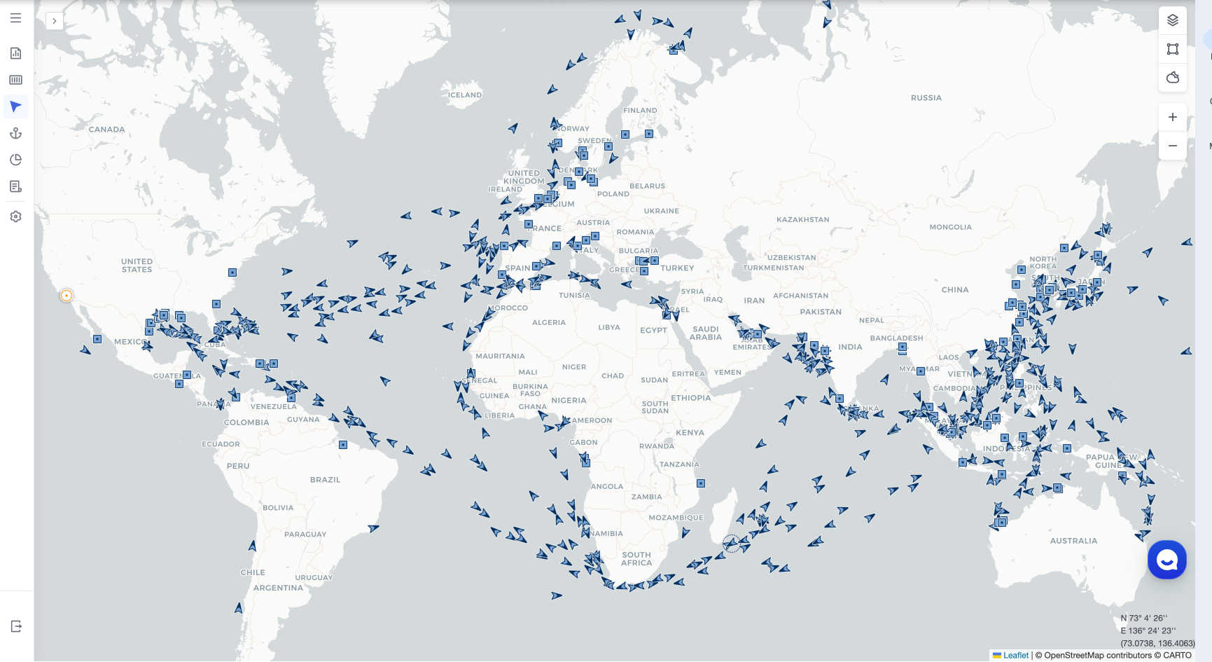
Track Any LNG Vessel in Real-Time
Enter a Master Bill of Lading, IMO, or Vessel Name to get instant location and ETA data.
Why Standard LNG Vessel Tracking Fails
In the high-stakes energy market, basic tracking isn't enough. Inaccurate data leads to flawed analysis and costly decisions. Our platform replaces unreliable information with a suite of precise, predictive tools designed for the nuances of LNG shipping.
Track the Global LNG Fleet with Precision
Monitor over 860 active LNG vessels—your own and your competitors'—with hyper-accurate, real-time AIS tracking, historical port call data, and complete vessel details, including IMO and operator information.
IMO 9923223 (BLUE WHALE)
Status: Under Way
Destination: Barcadera (AWBAR)
Your LNG Shipping Data, Your Way
Whether you need a ready-to-use platform or a powerful LNG vessel tracking API to feed your own systems, we have you covered.
Intuitive Web Dashboard
Get immediate access to our full suite of LNG tracking and analytics tools through our user-friendly web platform. No coding required.
Start Free Trial of DashboardBLUE WHALE
LNG Gas Carrier - 73,000 DWT
IMO: 9923223 | Call Sign: 5LRG6
Tongyeong (KRTYG) -> Barcadera (AWBAR)
ATD: 2025/08/27 08:21
PTA: 2025/10/01 14:45
AIS Info
2m ago (2025/08/28 04:23)
Navigation: Under way using engine
Coords: 33.4716, 126.3246
Powerful & Flexible API
Integrate our market-leading LNG shipping data directly into your own models, dashboards, and enterprise systems.
View API Documentation{
"vesselName": "BLUE WHALE",
"imo": "9923223",
"vesselType": "LNG_CARRIER",
"dwt": 73000,
"ais": {
"timestamp": "2025-08-28T04:23:00Z",
"latitude": 33.4716,
"longitude": 126.3246,
"speedKnots": 0.0,
"status": "UNDER_WAY_USING_ENGINE"
},
"voyage": {
"originPort": "KRTYG",
"destinationPort": "AWBAR",
"atd": "2025-08-27T08:21:00Z",
"eta": "2025-10-01T18:00:00Z",
"predictedETA": "2025-10-01T14:45:00Z"
}
}What is LNG Vessel Tracking?
LNG (Liquefied Natural Gas) carriers are highly specialized vessels designed to transport natural gas across oceans at a cryogenic temperature of -162°C (-260°F). The global fleet consists of roughly 860 of these high-value ships, making them a critical, trackable component of the global energy trade.
Effective LNG vessel tracking combines real-time AIS data with predictive ETAs and historical port call analytics to provide a true picture of market movements. This is the intelligence that allows traders and charterers to anticipate shifts in supply and demand, optimize vessel timing, and secure a competitive advantage in the volatile energy market.
A Complete Maritime Visibility Solution
Go beyond a single vessel type. Our platform provides deep, real-time visibility across the entire global fleet.
LNG Carrier Tracking
Optimize chartering and trading with predictive analytics for the entire LNG fleet.
Container Vessel Tracking
Gain SKU-level visibility and reduce D&D fees with the most accurate container data.
Tanker Tracking
Monitor oil, chemical, and gas tankers for competitive analysis and market timing.
Bulk Carrier Tracking
Track movements of raw materials and commodities to forecast supply and demand.
General Cargo Tracking
Monitor multi-purpose vessels and breakbulk shipments for project cargo logistics.
RORO Vessel Tracking
Track roll-on/roll-off cargo for automotive and heavy machinery supply chains.
Reefer Ship Tracking
Ensure cold chain integrity with real-time location and temperature monitoring data.
LPG Carrier Tracking
Gain an edge with specialized tracking for the global Liquefied Petroleum Gas fleet.
See the Difference Accuracy Makes.
Let our data experts provide a personalized demo focused on the trade routes and vessels that matter most to you. See firsthand how our platform can sharpen your competitive edge.
Frequently Asked Questions on LNG Vessel Tracking
How does your data accuracy compare to competitors like Kpler?
Our clients consistently report higher accuracy, particularly in our predictive ETAs and port congestion forecasts. We achieve this by leveraging a wider range of data sources and more advanced machine learning models, specifically tuned for the complexities of LNG transport.
Can we track specific competitor vessels?
Yes. Our platform tracks the entire global fleet of over 913 LNG vessels. We can provide you with a full list of IMO numbers, allowing your team to monitor any vessel of interest—whether it's part of your fleet or a competitor's.
How is the data delivered?
We offer flexible delivery options to suit your workflow. You can integrate our full dataset into your own systems via our robust, well-documented API, or you can access the same intelligence through our intuitive, ready-to-use web platform.
What is AIS data and why is it important for LNG tracking?
AIS (Automatic Identification System) is a satellite-based transponder system that broadcasts a vessel's identity, position, course, and speed. For LNG vessel tracking, AIS data is critical as it provides the real-time location foundation. We enrich this raw data with other sources to predict ETAs and analyze fleet movements with high accuracy.
How does weather impact LNG vessel tracking and ETAs?
Severe weather can significantly impact an LNG vessel's route and speed, causing delays. Our predictive ETA models incorporate real-time and forecasted weather data, allowing us to adjust arrival predictions more accurately than standard carrier ETAs, giving you a clearer picture of potential weather-related disruptions.
Can you track a vessel's cargo status (laden vs. ballast)?
Yes. By analyzing a vessel's draft, speed, and route patterns, our platform can determine with high confidence whether an LNG carrier is in a laden (carrying cargo) or ballast (empty) state. This is crucial for understanding cargo flows and predicting market supply.
Who are the largest operators of LNG carriers?
The global LNG fleet is operated by a mix of state-owned entities and private shipping companies. Some of the largest and most prominent operators include Nakilat (Qatar), Teekay LNG, Maran Gas Maritime, and NYK Line. Our platform allows you to monitor vessels from all major operators.
What are the primary global LNG trade routes?
The main LNG trade routes connect major production regions with key consumption markets. Major routes include Qatar to Asia (Japan, South Korea, China), Australia to Asia, and the United States to Europe and Asia. Our platform provides deep visibility into vessel traffic on all these critical arteries.

.png)